6. Visual Assessment within GIS
6.1 Visibility Analysis
A European Community's (EC) Directive on the 'Assessment of the Effects of Certain Public
and Private Projects on the Environment' ensured landscape changes are publicly assessed for their environmental
impact, including a statement on visual intrusion (McLaren & Kennie 1989). Before the use of geographical information
systems a range of methods were used to determine visual impact that often involved building three-dimensional
models or creating artistic impressions. However these are expensive and time consuming to create and "inherently
inaccurate and inflexible once created" (McLaren & Kennie 1989). More recent efforts to assess visual
intrusion take advantage of the improvement in GIS modelling and visualisation.
All the respected GIS books contain a description of visibility analysis, although the analytical
term varies. Viewshed analysis, intervisibility, line of sight calculation are other commonly used terms. Aronoff
(1989) concisely describes the viewshed as "the area that can be 'seen' (i.e. is in direct line-of-sight)
from the specified target locations." If any land or object rises in-between the line of sight of the two
points then that target area is not within the viewshed of the viewing location, therefore if no land rises above
the line of sight then the target is with in the viewshed. Figure 7 illustrates this operation. The function is
commonplace within commercial GIS packages and has proved itself invaluable for such diverse applications as locating
forest fire observation towers or radio antennae, assessing how well a road is hidden from view and by the military
to plan the least visible troop movements.
Figure 7. The Concept of Visibility in GIS
NOT YET AVAILABLE
(Source: Aronoff 1989)
Visibility maps may be created from grid-based or TIN terrain models. Depending upon the
sophistication of the GIS package used, the analysis can be enhanced by including additional data such as the height
of the viewer, a distance that the viewer is interested in, the height of different land covers that may block
views, a maximum and minimum height of visibility and the curvature of the earth (Fisher 1993).
6.2 The Application of Visibility Analysis
Before GIS a number of different approaches were used to assess visibility, for example research
by Hull and Bishop (1988) to assess the impact of electrical transmission towers compared photographs of the towers
and of similar landscapes without any towers. The public then assessed the scenes using a 10 point rating scale.
Whilst not a GIS procedure their research raised issues important to any landscape assessment. They found that
scenic impact decreases rapidly as distance increases, fitting an inverse relationship and that most of the scenic
impact transpires within a 1km range. However, the point when the visual impact becomes unacceptable to the people
viewing the landscape may occur at different distances, depending upon their purpose in viewing the landscape.
"Landscape type did have a statistically significant impact on this relationship. However, in general, the
largest impacts occurred in the rural landscapes which were high in scenic beauty, medium impacts occurred in residential
areas, and the smallest impacts occurred in a flat, barren, not very scenic landscape" (Hull & Bishop
1988).
Visibility analysis encompasses a wide range of possible applications, yet there is limited
literature available on the methods used in real world examples. Most available literature regarding visibility
examines its application in the forestry industry with regard to design planting and felling regimes that minimise
visual landscape impact. Research by Davidson, Watson and Selman (1993) however is particularly relevant to this
investigation. Although used in a retrospective capacity, they evaluate GIS "
as an aid to the planning of
proposed developments in rural areas" through four case studies. "One application of considerable importance,
prompted by statutory requirements for environmental assessment, has been the visual impact of new development
proposals. Hitherto, this has involved laborious manual techniques or protracted and expensive photographic editing.
Increased use is now being made of digital terrain models (DTMs) and associated overlays" (Davidson, Watson
& Selman 1993).
To provide an assessment of their analysis they held a workshop attended by various planners
and environmental professionals. Their response was very positive and the three-dimensional models created "
were
judged to be of particular value in providing effective landscape images" (Davidson, Watson & Selman 1993).
The evaluators found that such models were more useful than conventional maps, giving them a better perception
of the area and setting the development within the context of the landscape. The models increased confidence about
the precise location of the development, "
a very difficult task to do manually on landscape drawings by artists"
(Davidson, Watson & Selman 1993). Table 3 contains the advantages they determined
from their experience with visual assessment, equated with a number of possible problems. Potentially the most
problematic of these is the ease with which people can be seduced by high impact computer graphics. Whilst including
cost and time these problems have decreased with the dramatic improvement in processing power in the last few years.
Their research is significant in relation to this dissertation, as they have successfully
analysed the potential of a GIS role in the planning of rural developments. The first of their case studies considers
the impact of the new base station, infrastructure and chairlifts at the Aonach Mor Skiing development near Ben
Nevis where they directed their research "to determine whether GIS processing could offer assistance in terms
of assessing visual impact" (Davidson, Watson & Selman 1993). By draping a variety of vector files over
a DTM they were able to produce 'realistic' visualisations of the development. They began with a DTM of 20 metre-pixel
size but found that their visibility computations were taking over 10 hours and so increased the cell size to 50
metres, reducing computational time to 1 hour. Although processing times have improved this still illustrates that
visibility analysis is a computer intensive process.
They produced output for the following:
1. a visibility map for the top station,
2. a visibility map for the chairlift, showing areas with different degrees of visibility,
3. a visibility map of the development from the summit of Ben Nevis,
4. a visibility map of the development from a local beauty spot.
Besides the chairlift case study they followed the same approach when considering the impact
of an overhead power line on the Isle of Skye, an afforestation scheme on the Tinto Hills near Glasgow and an open-cast
mine, also near Glasgow. For the power line scheme a visibility map was produced for each pylon and then combined
to produce a composite visibility map that accumulated the visibility results. However they found the resultant
map was "
rather complicated, with a range of shadings for pylon visibility. To aid presentation the DTMs
were draped with a shading pattern corresponding to those areas within which at the most five pylons were visible"
(Davidson, Watson & Selman 1993).
Other practical examples in the literature assessing the role of GIS to determine visual
quality of a location, notably Miller, Morrice, Horne & Aspinall (1994), Miller & Law (1997) and Miller,
Brooker & Law (1998) who analysed scenery in the Cairngorms in Scotland. Miller Et al. (1994) surmises that
"
in the same manner that locations may be classified by altitude, land cover, or land use, they may also
be classified in terms of the amount of land visible from them." To assess 'scenic potential' they calculated
the number of viewpoints that each terrain location can see. In general they found that the highly visible land
is along the Spey Valley floor and the more mountainous regions have lower values because of their relatively enclosed
nature, although the mountain summit of Cairngorm was a notable exception. This assessment allows the delimiting
of areas that are the most sensitive to visual impact.
Another aspect of their research analysed land cover change, in which they raise a number
of important considerations when performing visibility analysis: decreasing size perspective with distance, the
angle of intersection of the view with the terrain and the effect of different land cover types. In their analysis
they incorporated a distance-decay function to "calculate visual clarity as the distance between an observer
and an object increases" (Miller Et al. 1994). Texture, colour, hue and brightness are land cover attributes
that provide the context against which to analysis visual impact. Miller et al. (1994) notes that impact increases
significantly when the contrasts in hue or brightness between background land cover and the object being viewed
are large.
Miller & Law (1997) and Miller, Brooker & Law (1997) produced a visibility census
for the whole of Scotland. However, instead of selecting viewpoints they located points at 5km intervals. Their
work also emphasises the intense computer processing needed for visibility calculations as their trial analysis
on an area of 40 x 40 points using the Grid module of Arc/Info took approximately twelve days.
6.3 The Accuracy of Visibility Analysis
As previously mentioned DTM data contains an inherent error, acknowledged in the reporting
of the RMSE, which reproduces itself into any analysis results. However, this is not the only source of inaccuracy.
An issue mentioned in a number of research articles that has received little attention is software quality, particularly
the degree to which different GIS packages that offer the same function may produce inconsistencies. Whilst the
need for software testing is widely accepted in the IT industry limited work has been done setting benchmarks within
GIS. Although many have called for it the requirement for testing "has been largely ignored in the drive for
standards in GIS which have concentrated on data transfer to the almost total exclusion of any others" (Fisher
1996). Knowing the accuracy of visibility analysis would greatly enhance the effectiveness of many of the applications
formerly mentioned.
Unlike most GIS functions the viewshed is almost impossible to verify in the field. The problem
is that almost everywhere some sort of vegetation covers the landscape to some height above the ground, which is
difficult to measure effectively. In addition complex effects such as atmospheric refraction, the earth's curvature
and the seasonal variation of vegetation, which are rarely included in the viewshed analysis, cause the calculated
line of sight to be different from the actual viewer's line of sight.
Fisher (1991, 1992, 1993, and 1995) has studied the effects of error in the calculation of
viewsheds. He examined three major features of the viewshed algorithms: how elevation is inferred from the DTM,
how the viewpoint and target are represented and the effect of the different algorithms used by different proprietary
GIS packages in their viewshed calculations.
Fisher (1996) finds that the second of these issues produces the greatest variability in
the viewshed, up to 50% of the viewable area. Comparing viewpoints and targets defined either as points or cells,
he determined that the use of points decreases the viewshed, which is perhaps expected since using a point as opposed
to the whole grid cell increases the accuracy of the analysis. He also discovered that the viewshed varies to a
lesser degree depending upon the method of inferring elevation but the scale of this effect depends upon the landscape.
Fisher has also examined the effect of the different algorithm designs used by proprietary
GIS packages in their viewshed calculation. Although he found differences in their results he does not implicitly
criticise any particular package as the results are all very similar to his control analysis value and none is
shown to be 'grossly' wrong. "All the programs tested seem to be 'correct', differences result from alternative
design decisions at the time that algorithms were specified by different groups. Those design decisions were undoubtedly
defensible and acceptable both at the time and now" (Fisher 1993).
The resulting output from the viewshed analysis is normally represented as a binary map,
with 1 indicating that the location is in-view and 0 where it is out-of-view. Fisher (1991, 1992, 1993, and 1995)
believes the variability in the viewshed is caused by minor changes in the parameters used and emphasises the inappropriateness
of binary representation. He developed the notion of a 'probable viewshed' using a Monte Carlo simulation approach
to "accommodate the errors which may occur in the process of deriving the viewable area" (Fisher 1995).
Using the existing Boolean nature of the viewshed analysis he inserted a sliding scale between 1 and 0 to indicate
the likelihood that it can be seen. He has also developed a second approach, the 'fuzzy viewshed' using a fuzzy
membership function that "
defines the degree to which any potential target can be distinguished" (Fisher
1996). This measure takes account of phenomenon such as the atmospheric attenuation of light, object-background
contrast, variable atmosphere conditions and the eyesight of the individual that all play some role in determining
whether an individual can distinguish an object.
Fisher's research implies no criticism of any particular GIS implementation of the visibility
functions as "
the viewshed is a fundamentally uncertain phenomenon within a GIS" that "
should
not be seen as a case of algorithm or implementation error, since all are assumed to be justifiable" (Fisher
1996).
6.4 Assessing Visibility of the Proposed Funicular
There is little doubt that the funicular railway and its associated buildings, particularly
the Ptarmigan complex will be clearly visible from the rest of the landscape. The track will appear as a continuous
linear feature extending from the Day Lodge to the tunnel entrance and "the railway carriages would provide
an obvious source of movement in the landscape, although that movement would not be continuous" (Highland
Regional Council 1996). The replacement buildings are larger than the existing structures and although they would
be seen against a mountain backdrop, the top station would be visible on the skyline from some areas of lower ground.
Another artificial feature in the landscape would be the entrance to the tunnel, whilst the route of the tunnel
will be visible for a number of years.
Figure 8. Viewing Parameters for Visibility Analysis
(Source: Aronoff 1989)
The Existing Structure
Before the visibility of the proposed funicular can be assessed the existing visibility of
the chairlifts and its associated structures needs to be determined. This can then be compared with the viewshed
created by the funicular and its associated buildings and an assessment made as to its visual impact. The visibility
command in the Grid module of Arc/Info determines which cells an observation location or locations can see. These
observation locations are determined from an input coverage and can be of either point or line feature type. The
command offers a number of options to control the analysis (Figure 8). "You can specify
observation point elevation values, vertical offsets, horizontal and vertical scanning angles and scanning distances"
(Arc/Info HyperHelp 1998). Inserting an item called OFFSETA in the attribute table of the coverage used as the
observation location indicates a vertical distance to be added to its existing 'z' value (elevation). This allows
two visibility calculations to be made for each location, the first using an OFFSETA of zero metres and the second
using the height of the structure.
The viewshed analysis was only performed on the structures that are due to be replaced by the funicular. The other ski lifts and pulls were ignored as they will remain whether the funicular development is giving the go ahead or not. Using the default height offset of one metre allowed the determination of the areas that can see the whole of the structure whilst inserting the structure's height determines the areas that can only see its uppermost point. Taking a lead from Fisher's work the difference in the results will be referred to as the 'fuzzy visible area', as a viewer positioned in these locations will only be able to view part of the structure. The existing structures for which a viewshed calculation was made are contained in Table 4, along with the OFFSETA value. This values contain a relatively high error factor as Highland Regional Council have no record of their exact height, therefore visual interpretation was required. The other control options were not applied as the analysis was concerned with the whole region.
Table 4. The Height of the Existing Structures
| Structure |
Height (m) |
| Day Lodge |
7 |
| White Lady Shieling |
6 |
| Ptarmigan Restaurant |
5 |
| Chairlift Pylons |
8 |
Whilst the buildings are all single observation locations there are 19 pylons, split between
the two. Using the FREQUENCY option with the visibility command produces a grid that records how many times each
area can be seen from the input coverage and following Davidson, Watson & Selman's (1993) example a composite
image was produced. This ignored the cables between the pylons as they are almost invisible compared to the pylons.
The Funicular and its Associated Structures
The same procedure was followed to analysis visibility for the new buildings and the tunnel
entrance as the existing structures. Their heights are recorded in Table 5.
Table 5. The Height of the Proposed Structures
| Structure |
Height (m) |
Increase (m) |
% Increase |
| Day Lodge |
14 |
7 |
100% |
| White Lady Shieling |
13 |
7 |
108% |
| Ptarmigan Restaurant |
12 |
7 |
120% |
| Tunnel Entrance |
3 |
- |
- |
A slightly different method was needed to calculate visibility for the track as its height
above the ground varies between 0m and 6m. The track is supported by a number of concrete pillars at equally spaced
intervals, which divide the track into 33 sectors. Using a cross-section plan of the funicular supplied by Highland
District Council the average track height for each of these sectors was calculated and the centre of each sector
recorded in a Arc/Info points coverage. As before an item entitled OFFSETA was added to its attribute table and
the average height for the corresponding sector inserted. The visibility command was then entered and a grid produced
containing the number of sector visible at each study area location.
The Tunnel
Although the last 250m of the railway track will be located underground in a 'cut and fill'
tunnel its route is likely to be visible for a number of years. Studies have shown that at the higher altitudes
the process of native species re-colonisation has been slow, taking around twenty-five years. "Until that
time, it is quite possible that the area of tunnel construction will form a visual scar on the side of the mountain,
within a National Scenic Area" (Highland Regional Council 1996). Thus, a visibility calculation will be made
for the tunnel's route. Two calculation were made, one with the assumption that if you were perpendicular with
it you would be able to see it, and the other assuming that the tunnel would not be visible if you moved 45 degrees
either side of the vertical angle, producing a fuzzy viewshed. Inserting items VERT1 and VERT2 in to the attribute
table controls the extent of the horizontal angle.
Visible Population
It is possible to calculate the approximate number of people that live within the viewshed
of the proposed funicular development. The smallest census collection unit used in Scotland for the 1991 census
is known as an Output Unit and their boundaries are available in Arc/Info export format from UKBorders. Based at
the University of Edinburgh this service allows members of the United Kingdom academic community access to a range
of digitised boundaries for use within geographic analysis. Thus, it was possible to extract the boundaries for
the census output units for the study region and import them into Arc/Info as a polygon coverage. Small Area Statistics
(SAS) that include total population for the 1991 Census are available from MIDAS (Manchester Information Datasets
and Associated Services), based at the University of Manchester. Using a command file (Appendix
1) to start the SASPAC extraction package I selected the total population for each Census Output Unit around
the Cairngorms. As each unit has an individual identity code it is possible to relate the MIDAS output to its relevant
polygon. This data then required clipping to the study region but before disposing of the area outside the population
density for each Output Unit needed calculating:
Population Density = Output Unit Area / Total Population
With population density calculated the census data polygon coverage can be clipped to the
study region and the relevant viewshed coverage overlaid. This coverage is converted from the output visibility
grid using the Gridpoly command. By transposing the above equation the total population for each Output Unit within
the viewshed can be estimated, and a simple sum of the Output Units using Arc/Info Statistics computes the population
living within the viewshed and its area. The procedure was followed to predict the total population living within
the viewshed of the existing chairlift and its' related buildings, and the funicular and its associated buildings.
Other Visible Landmarks
As the Cairngorms are a popular tourist destination there are a number of attractions in
the surrounding area, besides the chairlift. Whilst viewshed maps indicate the extent of the visibility it is interesting
to compare the visible extent of the chairlift/funicular from these selected features. The eight points were located
from an Ordnance Survey 1:25000 map of the area and an assessment made to the degree that the chairlift and funicular
would be visible from each of them. They consisted of four summits and four visitor centres, that is, places where
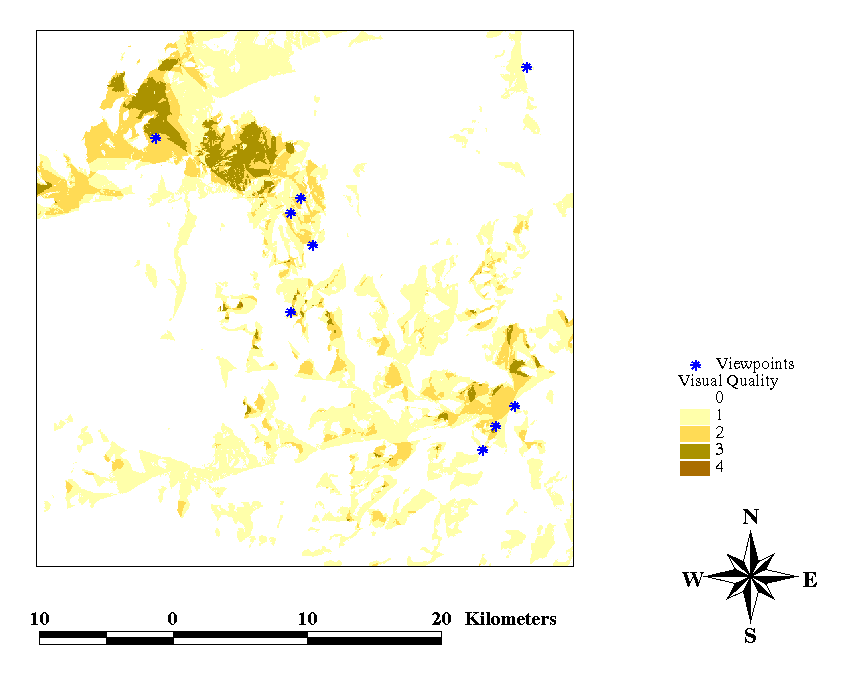
people tend to congregate (Figure 9). Taking this a step further a visual census was produced for the region following
the Miller, Morrice, Horne & Aspinall (1994) method (Figure 10) and a determination made
as to how visible the funicular would be from locations with the highest scenic quality. The viewpoint locations
were located from OS 1:50,000 maps of the area.
Figure 9. Location of Visble Landmarks
Figure 10. Visual Census Results

Last Updated 22-03-99